
HF - ALE SELCALL
Selective Calling
Automatic Link Establishment
Geo Position Report
Open Standard
ALE-GPR Format for AMD
ALE-GPR Fields for GPS
 |
HF - ALE SELCALL Selective Calling |
ALE-GPR Automatic Link Establishment Geo Position Report Open Standard ALE-GPR Format for AMD ALE-GPR Fields for GPS |
| Articles
- Information - Equipment ALE in the USA Amateur Radio Service |
Frequencies
- Channels Amateur ALE Channel List |
Experiments,
Testing, Software Beta Testing Group, PCALE Download |
||||||||||||||||||||||||||||||||||||||||||||||||||
| Open Standard ALE-GPR v1.1 |
||||||||||||||||||||||||||||||||||||||||||||||||||||
| Various
ALE radio manufacturers use proprietary methods of sending GPS via AMD,
and some are encoded or encrypted by proprietary signalling formats
(non-plain text). Open Standard ALE-GPR for GPS via ALE Automatic Link Establishment transmits GPS information in plain text. It is supported by HFLINK, the amateur radio ALE community, and various ALE controller systems. The open standard is called ALE Geo Position Report or ALE-GPR. To make the ALE-GPR "universal" for ALE transceivers and controllers, the coordinates and other information of the GPS position is transmitted as a human-readable AMD message. Example of ALE-GPR transmitted AMD: GPR*KQ6XA*37N654321*122W987654*000003M*20050821Z135235*EVERYTHING FINE Format ALE-GPR: GPR*OBJECT*LATITUDE*LONGITUDE*ALTITUDE*TIME*COMMENT A feature in the ALE controller PCALE provides this GPS position output to Google Earth. PCALE also provides an NMEA compatible GPS interface feature which converts and transmits ALE-GPR. Here is an example of a series of two ALE-GPRs sent as Netcall AMD (TWS) by KQ6XA in California and received by Jeff KB2M in New Jersey, using PCALE on both ends of the path: 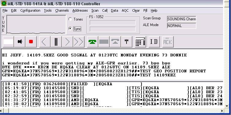 image courtesy of Jeff KB2M
Example audio file:
Standard Use of Geo Position Report with NETCALL and AMD TWS: Net name: GPR Sample *.wav file Netcall to the "GPR" Net address with the GPR in an AMD and TWS termination: KQ6XA_GPR_TEST.wav By using NETCALL for an open GPR, the receiving stations may "opt in" to a GPR Net. Individual stations can exchange GPRs using Individual Calls. |
||||||||||||||||||||||||||||||||||||||||||||||||||||
|
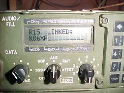
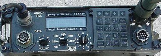
Manual keypad entry of ALE-GPR limits the characters that can be used.
It is important for ALE-GPR that the operator of the ALE transceiver,
having knowledge of their own position, be able to manually enter the
GPR as an AMD on the keypad of the ALE transceiver and send it. This
manual entry method would not require the electronic connection of a
GPS receiver to the HF transceiver or ALE controller, or modification
of the ALE controller
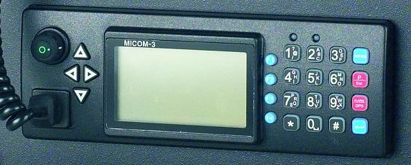
software/firmware. Displays on the front panels of some ALE
transceivers use simple LCD readouts with about 10 to 20 characters
displaying on a line. The AMD text is read by scrolling left/right with
an arrow key on the keypad. There are limitations on what characters read out on ALE transceivers. The following characters are common to all ALE displays and most transceiver keypads:
Any other character sent in the AMD has a risk that it might not show on the display. The ALE-GPR uses only 7 fields; with the * character as de-limiter: Example of transmitted AMD: GPR*KQ6XA*37N654321*122W987654*000003M*20050821Z135235*EVERYTHING FINE String field format ALE-GPR: GPR*OBJECT*LAxTITUDE*LONyGITUDE*ALTITUDf*YYYYMMDDZhhmmss*COMMENT HFLINK Standard ALE-GPR Fields
FCC Compliance: In addition to the global standard ALE protocols, the ALE-GPR documentation here provides the public documented technical characteristics called for in FCC rules § 97.309(a)(4) : "(4) An amateur station transmitting a RTTY or data emission using a digital code specified in this paragraph may use any technique whose technical characteristics have been documented publicly, such as CLOVER, G-TOR, or PacTOR, for the purpose of facilitating communications." "Documentation should be adequate to (a) recognize the technique or protocol when observed on the air, (b) determine call signs of stations in communication and read the content of the transmissions." |
||||||||||||||||||||||||||||||||||||||||||||||||||||
|
.End of page.. Back to top  . The fine print: ©2015-2001 HFLINK. All Rights Reserved. HFLINK, HF-LINK, HF LINK, and the HFLINK Logo are trademarks of HFLINK. Permission is granted for the HFLINK Logo to be used for non-commercial purposes only by amateur radio operators who are members in good standing of the HFLINK group for their QSL cards and personal websites for hyperlinking with the HFLINK.COM website only. The HFLINK Logo may be used by non-commercial or commercial websites only for the purpose of hyperlinking to the main page of the HFLINK.COM website http://hflink.com . Capture of the HFLINK website or any part of it within the frame of another website is not permitted. Public archiving, forwarding, or open display on the internet of the HFLINK egroup group forum is forbidden. All photos on the HFLINK website are property or copyright by HFLINK, or when used by permission, are copyright by their respective owners, with all rights reserved. No part of the HFLINK website or HFLINK Group Forum may be used or copied without written permission. HFLINK is a division of HFpack, Inc. . digital selective calling system HF interoperability automatic link establishment . . . . . . . . . . . . . . . . . . . . . . . . . . . . . . . . . . . . . . . . . . . . . . . . . . . . . . . . . . . . . . . . . . . . . . . . . . . . . . . . . . . . . . . . . . . . . . .
|